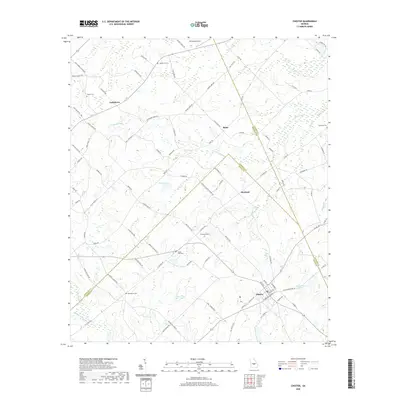
2020 Map of Chester
USGS Topo · Published 2020About this map
The town of Chester sits at the intersection of Dodge, Bleckley, and Laurens counties, serving as a focal point for this agrarian landscape in central Georgia. The area is defined by a network of rural roads such as Salem Church Rd and Macedonia Church Rd, which link small residential clusters and historical burial sites. Family and community heritage is anchored by several cemeteries, including Hinson Cem, Mullis Cole Cem, and Macedonia Cem, indicating long-standing settlement patterns in the vicinity of Goldsboro and Rebie.
Find a feature on this map
93 named features on this map. Tap any name to fly to it.
Don’t see what you’re looking for? This feature index may not catch every label — zoom into the map to look around manually.
Map Details
Editions of this 2020 Chester Map
This is the sole edition of this map. No revisions or reprints were ever made.
Other maps of this area

1956 · Cochran
USGS Topo · 1:62,500

1956 · Jeffersonville
USGS Topo · 1:62,500

1957 · Macon
USGS Topo · 1:250,000

1958 · Macon
USGS Topo · 1:250,000

1964 · Macon
USGS Topo · 1:250,000

1973 · Cadwell
USGS Topo · 1:24,000

1974 · Chester
USGS Topo · 1:24,000

1974 · Danville East
USGS Topo · 1:24,000

1974 · Dudley
USGS Topo · 1:24,000
1974 · Yonkers
USGS Topo · 1:24,000