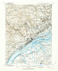
1894 Map of Chester
USGS Topo · Published 1963About this map
Chester sits at the heart of a dense industrial and transport corridor along the Delaware River, where numerous rail lines and creeks converge during the late 19th century. The landscape is a complex network of established settlements like Marcus Hook and emerging suburban clusters such as Lansdowne and Upper Darby. Inland, the terrain is defined by the steep drainages of Crum Creek and Ridley Creek, which provided power for earlier industrial sites like Sycamore Mills.
Find a feature on this map
208 named features on this map. Tap any name to fly to it.
Don’t see what you’re looking for? This feature index may not catch every label — zoom into the map to look around manually.
Map Details
Editions of this 1894 Chester Map
2 editions found
Other maps of this area

1890 · Salem
USGS Topo · 1:62,500

1890 · Glassboro
USGS Topo · 1:62,500

1891 · Philadelphia
USGS Topo · 1:62,500

1893 · Germantown
USGS Topo · 1:62,500

1894 · Chester
USGS Topo · 1:62,500

1894 · Philadelphia
USGS Topo · 1:62,500

1894 · Norristown
USGS Topo · 1:62,500

1894 · Germantown
USGS Topo · 1:62,500

1895 · Norristown
USGS Topo · 1:62,500

1896 · Germantown
USGS Topo · 1:62,500