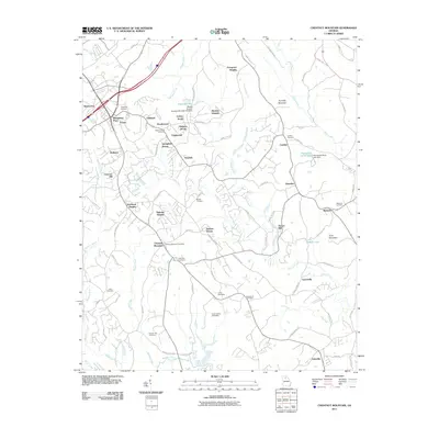
2011 Map of Chestnut Mountain
USGS Topo · Published 2011About this map
Chestnut Mountain serves as a prominent focal point in this Hall County landscape, surrounded by a complex network of residential developments and rural outposts. The area is marked by a high density of ancestral sites, including Redwine Cemetery, Poplar Springs Cemetery, and the Chestnut Mountain Cemetery, which offer significant value for genealogical research in the region. The map reveals a transition from traditional rural landmarks like Tanner Mill to modern recreational hubs, most notably the Lanier Speedway and Road Atlanta Speedway located near the Cooper Creek drainage.
Find a feature on this map
96 named features on this map. Tap any name to fly to it.
Don’t see what you’re looking for? This feature index may not catch every label — zoom into the map to look around manually.
Map Details
Editions of this 2011 Chestnut Mountain Map
This is the sole edition of this map. No revisions or reprints were ever made.
Other maps of this area

1891 · Gainesville
USGS Topo · 1:125,000

1954 · Greenville
USGS Topo · 1:250,000

1958 · Greenville
USGS Topo · 1:250,000

1964 · Hog Mountain
USGS Topo · 1:24,000

1964 · Chestnut Mountain
USGS Topo · 1:24,000
1964 · Winder North
USGS Topo · 1:24,000
1964 · Auburn
USGS Topo · 1:24,000

1964 · Gainesville
USGS Topo · 1:24,000
1964 · Chestatee
USGS Topo · 1:24,000

1964 · Pendergrass
USGS Topo · 1:24,000