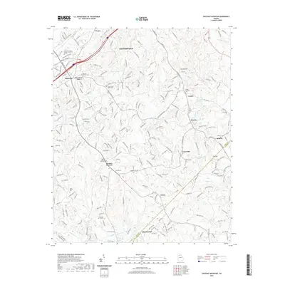
2020 Map of Chestnut Mountain
USGS Topo · Published 2020About this map
The University of North Georgia - Gainesville Campus anchors the northwestern corner of this Hall County landscape, situated near the expanding residential and commercial corridors of Oakwood and Blackshear Place. Moving southeast, the terrain transitions into a dense network of local routes like Old Oakwood Rd and Tumbling Creek Rd, which connect a series of historically significant burial grounds and congregations. Family and community heritage is deeply rooted here, evidenced by the numerous sites such as Redwine Methodist Cem and the Chestnut Mountain Church Cem in the community of Chestnut Mountain. The southeastern portion of the map is defined by the winding course of the Mulberry River and Mulberry Cr, illustrating the traditional watershed boundaries between Hall and Jackson counties. Local landmarks like Tanner Mill and Kennedy Mtn stand as notable points of reference in a region where agricultural roots meet modern suburban growth.
Find a feature on this map
233 named features on this map. Tap any name to fly to it.
Don’t see what you’re looking for? This feature index may not catch every label — zoom into the map to look around manually.
Map Details
Editions of this 2020 Chestnut Mountain Map
This is the sole edition of this map. No revisions or reprints were ever made.
Other maps of this area

1891 · Gainesville
USGS Topo · 1:125,000

1954 · Greenville
USGS Topo · 1:250,000

1958 · Greenville
USGS Topo · 1:250,000

1964 · Hog Mountain
USGS Topo · 1:24,000

1964 · Chestnut Mountain
USGS Topo · 1:24,000
1964 · Winder North
USGS Topo · 1:24,000
1964 · Auburn
USGS Topo · 1:24,000

1964 · Gainesville
USGS Topo · 1:24,000
1964 · Chestatee
USGS Topo · 1:24,000

1964 · Pendergrass
USGS Topo · 1:24,000