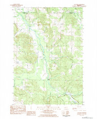
1983 Map of Chestonia
USGS Topo · Published 1984About this map
Mackinaw State Forest dominates this Antrim County landscape, where the Jordan River and its numerous tributaries, including Webster Creek and Lilak Creek, carve through the terrain. The map captures a rural network of farm-to-market roads and small settlements during the early 1980s. Local genealogy is well-preserved through several family and community landmarks, such as St Johns Cemetery, Trojanek Cemetery, and Rock Elm Cemetery. The presence of an Old RR Grade cutting through the forest suggests the area's earlier logging or industrial history, now replaced by a focus on recreation and conservation at sites like Graves Crossing and the Green River Ranch. Scattered hamlets like Chestonia, Finkton, and Mt Bliss serve as focal points for the surrounding township divisions of Echo, Jordan, and Chestonia.
Find a feature on this map
63 named features on this map. Tap any name to fly to it.
Don’t see what you’re looking for? This feature index may not catch every label — zoom into the map to look around manually.
Map Details
Editions of this 1983 Chestonia Map
This is the sole edition of this map. No revisions or reprints were ever made.
Other maps of this area

1954 · Traverse City
USGS Topo · 1:250,000

1955 · Cheboygan
USGS Topo · 1:250,000

1956 · Alba
USGS Topo · 1:62,500

1956 · Mancelona
USGS Topo · 1:62,500

1958 · Cheboygan
USGS Topo · 1:250,000

1958 · Traverse City
USGS Topo · 1:250,000

1961 · Boyne Falls
USGS Topo · 1:62,500

1961 · Boyne City
USGS Topo · 1:62,500

1975 · Mancelona NE
USGS Topo · 1:24,000

1975 · Mancelona NW
USGS Topo · 1:24,000