
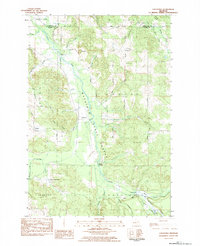
1975 Map of Mancelona NW
USGS Topo · Published 1976About this map
The village of Bellaire sits at the northern edge of this 1975 orthophoto, serving as the central hub of this Antrim County landscape. Most prominent is the dark expanse of Lake Bellaire, which dominates the western half of the quadrangle with its distinct shoreline and surrounding wooded terrain. As an orthophotograph rather than a traditional line-drawn map, this document provides a direct visual record of the mid-1970s land use, capturing the transition from the dense residential grid of the village to the agricultural fields and forested tracts that define the region. The aerial imagery clearly reveals the development patterns along the lakefront and the patchwork of clearings in the hills to the east, offering a precise view of the rural Michigan interior before more modern subdivisions altered the layout of these lakeside communities.
Find a feature on this map
2 named features on this map. Tap any name to fly to it.
Don’t see what you’re looking for? This feature index may not catch every label — zoom into the map to look around manually.
Map Details
Editions of this 1975 Mancelona NW Map
This is the sole edition of this map. No revisions or reprints were ever made.
Other maps of this area

1954 · Central Lake
USGS Topo · 1:62,500

1954 · Traverse City
USGS Topo · 1:250,000

1955 · Cheboygan
USGS Topo · 1:250,000

1956 · Mancelona
USGS Topo · 1:62,500

1957 · Elk Rapids
USGS Topo · 1:62,500

1958 · Cheboygan
USGS Topo · 1:250,000

1958 · Traverse City
USGS Topo · 1:250,000

1961 · Boyne City
USGS Topo · 1:62,500

1975 · Mancelona NE
USGS Topo · 1:24,000
1983 · Chestonia
USGS Topo · 1:25,000