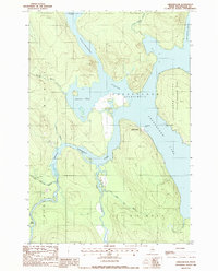
1988 Map of Chesuncook
USGS Topo · Published 1988About this map
Chesuncook sits as a lonely outpost on a peninsula within the expansive waters of Chesuncook Lake in this late-twentieth-century study of the Maine woods. The landscape is defined by the convergence of major waterways, where the West Branch of the Penobscot River meets the lake alongside Pine Stream. This area highlights the transition from industrial timber land to protected space, notably featuring the Gero Island State Reserve Land to the east. The geography is characterized by intricate shorelines and family-named or descriptive landmarks like Graveyard Point and Brandy Pond. Several Gravel Pits are the only signs of extractive activity in an otherwise remote wilderness of marshes and woods. The map preserves the township boundaries of the West Branch of the Penobscot River (W.E.L.S.), reflecting the historical organization of these unincorporated territories.
Find a feature on this map
25 named features on this map. Tap any name to fly to it.
Don’t see what you’re looking for? This feature index may not catch every label — zoom into the map to look around manually.
Map Details
Editions of this 1988 Chesuncook Map
This is the sole edition of this map. No revisions or reprints were ever made.
Other maps of this area

1954 · Chesuncook
USGS Topo · 1:62,500

1954 · North East Carry
USGS Topo · 1:62,500

1954 · Caucomgomoc Lake
USGS Topo · 1:62,500

1954 · Grant Farm
USGS Topo · 1:62,500

1954 · Presque Isle
USGS Topo · 1:250,000

1954 · Millinocket
USGS Topo · 1:250,000

1958 · Presque Isle
USGS Topo · 1:250,000

1958 · Millinocket
USGS Topo · 1:250,000

1958 · Chesuncook
USGS Topo · 1:62,500

1958 · Caucomgomoc Lake
USGS Topo · 1:62,500