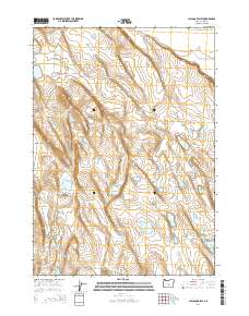
2014 Map of Chicago Valley
USGS Topo · Published 2014About this map
Chicago Valley and Browns Valley dominate this arid landscape in Lake County, Oregon. The terrain is defined by its vital water sources, as indicated by a dense network of named waterholes and seasonal basins. This concentration of water points, such as Juniper Waterhole, Musser Waterhole, and One Crock Waterhole, reveals the critical infrastructure required for ranching or survival in the high desert environment. The eastern edge of the quadrangle is bounded by the dramatic rise of the Stauffer Rim, while the southwest corner is marked by the prominence of Frederick Butte. Remote tracks like Benjamin Lk and the Chicago Vly road provide the primary means of navigating this expansive and sparsely settled territory, which remains subdivided by the Public Land Survey System boundaries of t24s r21e and its neighbors.
Find a feature on this map
20 named features on this map. Tap any name to fly to it.
Don’t see what you’re looking for? This feature index may not catch every label — zoom into the map to look around manually.
Map Details
Editions of this 2014 Chicago Valley Map
This is the sole edition of this map. No revisions or reprints were ever made.
Other maps of this area

1955 · Crescent
USGS Topo · 1:250,000

1957 · Crescent
USGS Topo · 1:250,000

1958 · Crescent
USGS Topo · 1:250,000

1970 · Crescent
USGS Topo · 1:250,000
1981 · Tired Horse Butte
USGS Topo · 1:24,000

1981 · Sand Rock
USGS Topo · 1:24,000

1981 · Moonlight Butte
USGS Topo · 1:24,000

1981 · Elk Butte
USGS Topo · 1:24,000
1981 · Rams Butte
USGS Topo · 1:24,000

1981 · Chicago Valley
USGS Topo · 1:24,000