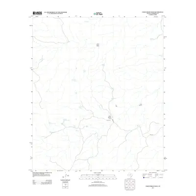
2012 Map of Chico Draw West
USGS Topo · Published 2012About this map
Chico Ranch anchors this arid portion of Culberson County, where the landscape is defined by an extensive network of water management features essential for ranching. The terrain is marked by numerous draws and canyons, including Seep Spring Draw, Leed Canyon, and Rock House Draw, which provide natural drainage through the high desert. To support livestock in this environment, the map reveals a high concentration of named tanks such as Goodfellow Tanks, Deadhorse Tank, and Paula Tank. Significant elevations like N Mtn overlook the winding paths of Madera Rd and Stone Rd, reflecting the sparse but functional infrastructure of the Trans-Pecos region. This 2012 survey provides a clear view of how topographic features and man-made water catchments like Double Spillway Tank dictate the utility of this remote Texas land.
Find a feature on this map
26 named features on this map. Tap any name to fly to it.
Don’t see what you’re looking for? This feature index may not catch every label — zoom into the map to look around manually.
Map Details
Editions of this 2012 Chico Draw West Map
This is the sole edition of this map. No revisions or reprints were ever made.
Other maps of this area

1933 · Guadalupe Peak
USGS Topo · 1:48,000

1940 · Guadalupe Peak
USGS Topo · 1:62,500

1954 · Van Horn
USGS Topo · 1:250,000

1958 · Van Horn
USGS Topo · 1:250,000

1973 · Chico Draw East
USGS Topo · 1:24,000

1973 · Cow Mountain
USGS Topo · 1:24,000

1973 · Bitter Well Mountain
USGS Topo · 1:24,000

1973 · Burro Canyon
USGS Topo · 1:24,000
1973 · Emory Corral
USGS Topo · 1:24,000
1973 · Long Point
USGS Topo · 1:24,000