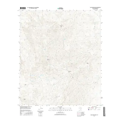
2016 Map of Chico Draw West
USGS Topo · Published 2016About this map
Chico Draw and its surrounding canyons define this arid landscape in Culberson County, where the management of water is the primary human footprint. A complex network of catchment features, including Goodfellow Tanks, Seep Spring Tank, and the uniquely named Double Spillway Tank, indicates the vital infrastructure required for ranching in this high-desert environment. The terrain is deeply incised by drainages such as North Rock Draw and Rock House Draw, which cut toward the lower elevations of No Mans Canyon. Access throughout this remote territory is limited, primarily facilitated by the solitary Stone Rd winding through the south. The topographic detail reveals a landscape of high ridges like N Mtn and deep passages like Leed Canyon, where historical land use is marked by small-scale modifications of the natural hydrology.
Find a feature on this map
28 named features on this map. Tap any name to fly to it.
Don’t see what you’re looking for? This feature index may not catch every label — zoom into the map to look around manually.
Map Details
Editions of this 2016 Chico Draw West Map
This is the sole edition of this map. No revisions or reprints were ever made.
Other maps of this area

1933 · Guadalupe Peak
USGS Topo · 1:48,000

1940 · Guadalupe Peak
USGS Topo · 1:62,500

1954 · Van Horn
USGS Topo · 1:250,000

1958 · Van Horn
USGS Topo · 1:250,000

1973 · Chico Draw East
USGS Topo · 1:24,000

1973 · Cow Mountain
USGS Topo · 1:24,000

1973 · Bitter Well Mountain
USGS Topo · 1:24,000

1973 · Burro Canyon
USGS Topo · 1:24,000
1973 · Emory Corral
USGS Topo · 1:24,000
1973 · Long Point
USGS Topo · 1:24,000