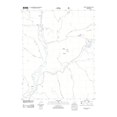
2011 Map of Chimney Rock
USGS Topo · Published 2011About this map
The Chimney Rock Archeological Area stands as the central landmark of this terrain, marking a site of significant cultural and historical importance. Nearby, the presence of the Chimney Rock Coal Mine points to the area's more recent industrial history, while the Chimney Rock Post Office serves the small settlement of Piedra. The landscape is defined by the Piedra River and its numerous tributaries, including Stollsteimer Creek and Devil Creek, which cut through the canyons and gulches. To the south, the settlement of Stollsteimer is situated near the confluence of several waterways. Water management and recreation are evident at the Pargin Reservoir and its associated Pargin Dam, alongside Capote Lake. This modern survey details the network of U.S. Forest Service roads, such as Usfs 617 and Usfs 627, which provide access to campgrounds like Lower Piedra Campground and Navajo Trail Campground.
Find a feature on this map
43 named features on this map. Tap any name to fly to it.
Don’t see what you’re looking for? This feature index may not catch every label — zoom into the map to look around manually.
Map Details
Editions of this 2011 Chimney Rock Map
This is the sole edition of this map. No revisions or reprints were ever made.
Other maps of this area

1924 · Pagosa Springs
USGS Topo · 1:125,000

1927 · Pagosa Springs
USGS Topo · 1:125,000

1945 · Durango
USGS Topo · 1:250,000

1953 · Durango
USGS Topo · 1:250,000

1954 · Durango
USGS Topo · 1:250,000

1954 · Allison
USGS Topo · 1:24,000

1954 · Carracas
USGS Topo · 1:24,000

1957 · Pagosa Junction
USGS Topo · 1:62,500

1961 · Durango
USGS Topo · 1:250,000

1963 · Durango
USGS Topo · 1:250,000