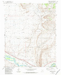
1983 Map of Chimney Rock
USGS Topo · Published 1984About this map
The Hogback ridge dominates the eastern landscape of this San Juan County region, where the industrial extraction of the late 20th century meets tribal lands. The map illustrates a complex network of resource management, including the extensive Horseshoe Gallup Oil Field and scattered oil wells across the Sand Hills. These energy operations share the territory with the Ute Mountain Indian Reservation and the Navajo Indian Reservation, divided by sectional boundaries.
Find a feature on this map
26 named features on this map. Tap any name to fly to it.
Don’t see what you’re looking for? This feature index may not catch every label — zoom into the map to look around manually.
Map Details
Editions of this 1983 Chimney Rock Map
This is the sole edition of this map. No revisions or reprints were ever made.
Other maps of this area

1889 · Chaco
USGS Topo · 1:250,000

1892 · Chaco
USGS Topo · 1:250,000

1927 · Sulphur Spring
USGS Topo · 1:96,000

1928 · Kirtland
USGS Topo · 1:125,000

1932 · Kirtland
USGS Topo · 1:125,000

1934 · Chimney Rock
USGS Topo · 1:62,500

1936 · Chimney Rock
USGS Topo · 1:62,500

1954 · Shiprock
USGS Topo · 1:250,000

1958 · Shiprock
USGS Topo · 1:250,000

1959 · Shiprock
USGS Topo · 1:250,000