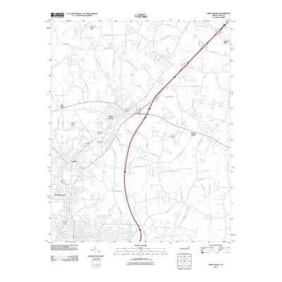
2010 Map of China Grove
USGS Topo · Published 2010About this map
China Grove serves as the central hub of this 2010 survey, illustrating a landscape defined by its position between the industrial corridors of Rowan and Cabarrus Counties. The transition from the established community of Landis and the northern reaches of North Kannapolis toward more open territory in Bostian Heights reveals the modern suburban expansion of the era. The map traces the winding paths of Cold Water Creek and Grants Creek, which break up the geometric grid of residential developments and agricultural holdings. Notable local landmarks like the China Grove Airport and the sprawling grounds of West Lawn Memorial Park provide specific points of interest for local historians. In the northern reaches, the terrain rises slightly toward Orchard Hills and Mount Girl- Bradley Field, while the southern border is anchored by the waters of Lake Fisher, reflecting the region's reliance on managed water resources for its growing population.
Find a feature on this map
71 named features on this map. Tap any name to fly to it.
Don’t see what you’re looking for? This feature index may not catch every label — zoom into the map to look around manually.
Map Details
Editions of this 2010 China Grove Map
This is the sole edition of this map. No revisions or reprints were ever made.
Other maps of this area

1893 · Statesville
USGS Topo · 1:125,000

1941 · Charlotte
USGS Topo · 1:125,000

1942 · Charlotte
USGS Topo · 1:125,000

1949 · Kannapolis
USGS Topo · 1:24,000

1950 · Concord
USGS Topo · 1:24,000

1953 · Charlotte
USGS Topo · 1:250,000

1954 · Charlotte
USGS Topo · 1:250,000

1957 · Mount Pleasant
USGS Topo · 1:62,500

1960 · Charlotte
USGS Topo · 1:250,000

1962 · Charlotte
USGS Topo · 1:250,000