
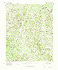
1957 Map of Mount Pleasant
USGS Topo · Published 1958About this map
The Reed Gold Mine (Inactive) remains a focal point in this 1957 landscape, marking the site where American gold was first discovered decades prior. Located in the southwest corner of the sheet, the mine sits near Georgeville and the Rocky River. This era shows a well-established network of rural communities, notably Mount Pleasant, Misenheimer, and Richfield, connected by the Carolina and Northwestern Ry. The map reveals a high density of rural institutions, such as Pfeiffer College in the north and numerous family-named landmarks like Barriers Mill and Plyler Cem. The terrain transitions from the Flat Woods toward the rising Hills in the east, with drainage dominated by Dutch Buffalo Creek and Running Creek. These watercourses supported local industry, evidenced by Whitley Mill and the scattered hamlets of Furr and Almond townships.
Find a feature on this map
87 named features on this map. Tap any name to fly to it.
Don’t see what you’re looking for? This feature index may not catch every label — zoom into the map to look around manually.
Map Details
Editions of this 1957 Mount Pleasant Map
2 editions found
Other maps of this area

1893 · Statesville
USGS Topo · 1:125,000

1941 · Charlotte
USGS Topo · 1:125,000

1942 · Charlotte
USGS Topo · 1:125,000

1949 · High Rock
USGS Topo · 1:24,000

1949 · Midland
USGS Topo · 1:24,000

1949 · Concord SE
USGS Topo · 1:24,000

1950 · Concord
USGS Topo · 1:24,000

1953 · Charlotte
USGS Topo · 1:250,000

1954 · Charlotte
USGS Topo · 1:250,000

1957 · Albemarle
USGS Topo · 1:62,500