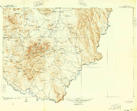
1905 Map of Chisos Mountains
USGS Topo · Published 1949About this map
Stroud's Ranch and the isolated settlement of Boquillas anchor this turn-of-the-century portrait of the Big Bend region along the Rio Grande. The landscape is defined by its water sources, from the evocatively named Smallpox Well and Dugout Wells to natural rock basins like Ernst Tinaja. These vital points, alongside Lindsey's Mine and the Old Smelter, reveal the tenuous human presence in a terrain dominated by the Rosillos Mountains and Chisos Mountains.
Find a feature on this map
133 named features on this map. Tap any name to fly to it.
Don’t see what you’re looking for? This feature index may not catch every label — zoom into the map to look around manually.
Map Details
Editions of this 1905 Chisos Mountains Map
2 editions found
Other maps of this area

1903 · Chisos Mountains
USGS Topo · 1:125,000

1903 · Terlingua
USGS Topo · 1:125,000

1904 · Terlingua
USGS Topo · 1:125,000

1905 · Chisos Mountains
USGS Topo · 1:125,000

1917 · Agua Fria
USGS Topo · 1:62,500

1917 · Bone Spring
USGS Topo · 1:62,500

1918 · Bone Spring
USGS Topo · 1:125,000

1918 · Bone Spring
USGS Topo · 1:62,500

1918 · Nine Point Mesa
USGS Topo · 1:62,500

1919 · Maravillas Canyon
USGS Topo · 1:62,500