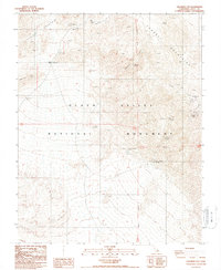
1988 Map of Chloride City
USGS Topo · Published 1988About this map
The Grapevine Mountains and Funeral Mountains dominate this rugged sector of the Death Valley National Monument as it appeared in the late 1980s. The map captures the remains of early desert industry, most notably at the Chloride City (Site) and nearby Chloride Cliff, where numerous prospects and ruins indicate a history of silver and lead mining. To the south, the Keane Wonder Mine sits perched above the valley floor, supported by a network of 4WD trails and proximity to Keane Wonder Springs. The landscape is defined by extreme topography, from the low-lying reaches of Death Valley to the prominent Death Valley Buttes and the aptly named Hells Gate. Scattered water sources like Monarch Spring and Hole in the Rock Spring illustrate the critical reliance on isolated springs for survival in this arid environment.
Find a feature on this map
26 named features on this map. Tap any name to fly to it.
Don’t see what you’re looking for? This feature index may not catch every label — zoom into the map to look around manually.
Map Details
Editions of this 1988 Chloride City Map
2 editions found
Other maps of this area

1908 · Furnace Creek
USGS Topo · 1:250,000

1908 · Ballarat
USGS Topo · 1:250,000

1910 · Furnace Creek
USGS Topo · 1:250,000

1913 · Ballarat
USGS Topo · 1:250,000

1942 · Bullfrog
USGS Topo · 1:125,000

1948 · Death Valley
USGS Topo · 1:250,000

1952 · Chloride Cliff
USGS Topo · 1:50,000

1952 · Stovepipe Wells
USGS Topo · 1:62,500

1954 · Bullfrog
USGS Topo · 1:62,500

1954 · Death Valley
USGS Topo · 1:250,000