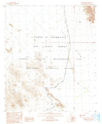
1990 Map of Christmas Pass
USGS Topo · Published 1991About this map
Christmas Pass provides a vital corridor through the arid divide of the Cabeza Prieta Mountains, where the landscape transitions into the wide Tule Desert. This 1990 survey captures a region dominated by conservation and military boundaries, specifically the Barry M Goldwater Air Force Range and the Cabeza Prieta Wilderness and National Wildlife Refuge.
Find a feature on this map
17 named features on this map. Tap any name to fly to it.
Don’t see what you’re looking for? This feature index may not catch every label — zoom into the map to look around manually.
Map Details
Editions of this 1990 Christmas Pass Map
This is the sole edition of this map. No revisions or reprints were ever made.
Other maps of this area

1953 · Ajo
USGS Topo · 1:250,000

1957 · Ajo
USGS Topo · 1:250,000

1958 · Ajo
USGS Topo · 1:250,000

1962 · Ajo
USGS Topo · 1:250,000

1963 · Ajo
USGS Topo · 1:250,000

1965 · Cabeza Prieta Peak
USGS Topo · 1:62,500
1965 · Tule Mountains
USGS Topo · 1:62,500

1965 · Isla Pinta
USGS Topo · 1:62,500

1965 · Sierra Arida
USGS Topo · 1:62,500

1967 · Ajo
USGS Topo · 1:250,000