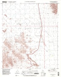
1996 Map of Christmas Pass
USGS Topo · Published 2000About this map
The Cabeza Prieta Mountains and the Sierra Pinta dominate this high-desert landscape in Yuma County, illustrating the transition between military and conservation lands during the late 1990s. The map clearly delineates the Wilderness Boundary separating the Barry M Goldwater Air Force Range from the Cabeza Prieta National Wildlife Refuge. This administrative division overlays a terrain defined by arid drainage systems like Smoke Tree Wash, Tule Wash, and Mohawk Wash. Evidence of human activity is scarce but significant, centered on the Christmas Pass transit point and isolated water sources such as North Pinta Tank and Senita Tank. Near the southern end of the Drift Hills, a labeled Prospect suggests the region's history of mineral exploration within this otherwise protected desert expanse.
Find a feature on this map
19 named features on this map. Tap any name to fly to it.
Don’t see what you’re looking for? This feature index may not catch every label — zoom into the map to look around manually.
Map Details
Editions of this 1996 Christmas Pass Map
This is the sole edition of this map. No revisions or reprints were ever made.
Other maps of this area

1953 · Ajo
USGS Topo · 1:250,000

1957 · Ajo
USGS Topo · 1:250,000

1958 · Ajo
USGS Topo · 1:250,000

1962 · Ajo
USGS Topo · 1:250,000

1963 · Ajo
USGS Topo · 1:250,000

1965 · Cabeza Prieta Peak
USGS Topo · 1:62,500
1965 · Tule Mountains
USGS Topo · 1:62,500

1965 · Isla Pinta
USGS Topo · 1:62,500

1965 · Sierra Arida
USGS Topo · 1:62,500

1967 · Ajo
USGS Topo · 1:250,000