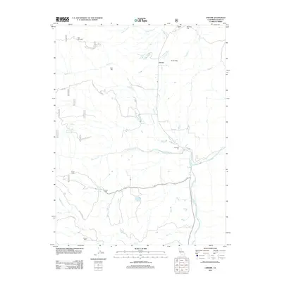
2012 Map of Chrome
USGS Topo · Published 2012About this map
Chrome and its surrounding ranchlands sit at the western edge of the Sacramento Valley, where the foothills begin their ascent toward the coastal ranges. This landscape is defined by the drainage systems of Grindstone Cr and Stony Cr, which flow through a network of ridges and gaps. Local history is anchored by familial sites like Gillaspy Ranch and Rowcroft Ranch, along with the quiet markers of early settlement at Millsap Cem and Grindstone Cem. The presence of the Powder House near the forest routes suggest the area's legacy of resource management and early infrastructure. Topographical landmarks such as Red Mountain and Rocky Ridge overlook a complex of water management features, including the Dry Lake Reservoir and East Reservoir, illustrating the critical role of water diversion in this semi-arid California environment.
Find a feature on this map
36 named features on this map. Tap any name to fly to it.
Don’t see what you’re looking for? This feature index may not catch every label — zoom into the map to look around manually.
Map Details
Editions of this 2012 Chrome Map
This is the sole edition of this map. No revisions or reprints were ever made.
Other maps of this area

1919 · Fruto
USGS Topo · 1:62,500

1919 · Elk Creek
USGS Topo · 1:62,500

1944 · Fruto
USGS Topo · 1:62,500

1944 · Flournoy
USGS Topo · 1:62,500

1948 · Elk Creek
USGS Topo · 1:62,500

1952 · Paskenta
USGS Topo · 1:62,500

1957 · Elk Creek
USGS Topo · 1:62,500

1957 · Ukiah
USGS Topo · 1:250,000
1958 · Fruto
USGS Topo · 1:62,500
1958 · Flournoy
USGS Topo · 1:62,500