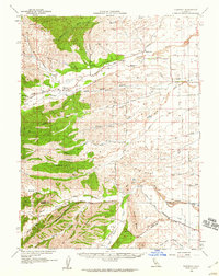
1958 Map of Flournoy
USGS Topo · Published 1959About this map
Flournoy and Henleyville anchor this 1950s interior view of the Sacramento Valley foothills, showing a landscape defined by seasonal watercourses and evolving infrastructure. The map details the transition from the rugged western peaks like Table Mountain and Butte Mountain to the agricultural plains to the east. Water management is a central theme, evidenced by the Orland Buttes Canal and a Diversion Dam on Stony Creek, reflecting the importance of irrigation to the Tehama and Glenn county borderlands during this era.
Find a feature on this map
59 named features on this map. Tap any name to fly to it.
Don’t see what you’re looking for? This feature index may not catch every label — zoom into the map to look around manually.
Map Details
Editions of this 1958 Flournoy Map
This is the sole edition of this map. No revisions or reprints were ever made.
Other maps of this area

1890 · Red Bluff
USGS Topo · 1:250,000

1894 · Red Bluff
USGS Topo · 1:250,000

1904 · Vina
USGS Topo · 1:62,500

1904 · Walker Creek
USGS Topo · 1:31,680

1905 · Tehama
USGS Topo · 1:62,500

1906 · Willows
USGS Topo · 1:62,500

1914 · Kirkwood
USGS Topo · 1:31,680

1914 · Orland
USGS Topo · 1:31,680

1919 · Fruto
USGS Topo · 1:62,500

1919 · Elk Creek
USGS Topo · 1:62,500