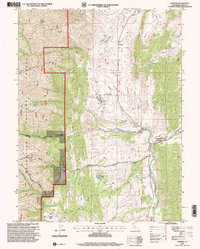
1995 Map of Chrome
USGS Topo · Published 2001About this map
Mining history and ranching legacies intersect in this mid-1990s survey of the foothills in Glenn County. The eponymous settlement of Chrome serves as a focal point for an area defined by mineral extraction, evidenced by the presence of the Chrome Mine, Black Diamond Mine, and Gray Eagle Mine near Red Mountain. The landscape transitions from the open grazing lands of the Gillaspy Ranch and Rowcroft Ranch to the dense, protected terrain of the Mendocino National Forest.
Find a feature on this map
36 named features on this map. Tap any name to fly to it.
Don’t see what you’re looking for? This feature index may not catch every label — zoom into the map to look around manually.
Map Details
Editions of this 1995 Chrome Map
This is the sole edition of this map. No revisions or reprints were ever made.
Other maps of this area

1919 · Fruto
USGS Topo · 1:62,500

1919 · Elk Creek
USGS Topo · 1:62,500

1944 · Fruto
USGS Topo · 1:62,500

1944 · Flournoy
USGS Topo · 1:62,500

1948 · Elk Creek
USGS Topo · 1:62,500

1952 · Paskenta
USGS Topo · 1:62,500

1957 · Elk Creek
USGS Topo · 1:62,500

1957 · Ukiah
USGS Topo · 1:250,000
1958 · Fruto
USGS Topo · 1:62,500
1958 · Flournoy
USGS Topo · 1:62,500