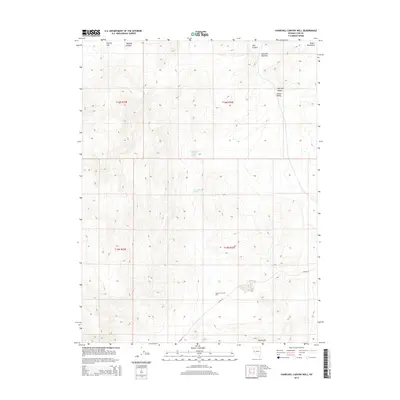
2014 Map of Churchill Canyon Well
USGS Topo · Published 2014About this map
Churchill Canyon serves as the central drainage for this arid high-desert landscape in Lyon County, where survival historically depended on the sparse water sources noted here. Vital water points such as the Churchill Canyon Well, Churchill Canyon Spring, and Churchill Spring are documented alongside the topographical features that define the region's ranching and travel history. The map illustrates a network of deep ravines including Mineral Canyon and Mill Canyon, which cut through the high ground toward the Adrian Valley. Broad expanses like Clifton Flat and the rocky outcrops of Blackrock at the southern edge reveal the open, undeveloped character of this territory in the 21st century. The narrow passage of Churchill Narrows and the solitary track of Julian Ln provide evidence of the limited but essential routes used to navigate between the high Desert Mountains and the valley floor.
Find a feature on this map
16 named features on this map. Tap any name to fly to it.
Don’t see what you’re looking for? This feature index may not catch every label — zoom into the map to look around manually.
Map Details
Editions of this 2014 Churchill Canyon Well Map
This is the sole edition of this map. No revisions or reprints were ever made.
Other maps of this area

1891 · Wabuska
USGS Topo · 1:125,000

1894 · Wabuska
USGS Topo · 1:125,000

1957 · Como
USGS Topo · 1:62,500

1957 · Wabuska
USGS Topo · 1:62,500

1957 · Churchill Butte
USGS Topo · 1:62,500

1957 · Silver Springs
USGS Topo · 1:62,500

1957 · Reno
USGS Topo · 1:250,000

1959 · Reno
USGS Topo · 1:250,000

1960 · Reno
USGS Topo · 1:250,000

1979 · Carson City
USGS Topo · 1:100,000