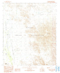
1990 Map of Cimarron Peak
USGS Topo · Published 1991About this map
The Papago Indian Reservation defines this landscape in southern Arizona, where desert plains meet sharp rises. The terrain is structured by the Sauceda Mountains to the north and the prominent Cimarron Peak to the east, overlooking the broad expanse of Kaka Valley. This 1990 provisional sheet captures the area's sparse but significant human footprint, featuring the settlement of Emika and the archaeological location at Tatai Toak (Site). A small Cem (cemetery) is noted near the southern foothills, providing a specific point of interest for genealogists and researchers. Drainage is dominated by Hickiwan Wash, which threads through the Hickiwan Valley, indicating the seasonal water patterns that have historically shaped movement and settlement in this arid environment.
Find a feature on this map
13 named features on this map. Tap any name to fly to it.
Don’t see what you’re looking for? This feature index may not catch every label — zoom into the map to look around manually.
Map Details
Editions of this 1990 Cimarron Peak Map
This is the sole edition of this map. No revisions or reprints were ever made.
Other maps of this area

1953 · Ajo
USGS Topo · 1:250,000

1957 · Ajo
USGS Topo · 1:250,000

1958 · Ajo
USGS Topo · 1:250,000

1958 · Kaka
USGS Topo · 1:62,500

1958 · Hat Mountain
USGS Topo · 1:62,500

1962 · Ajo
USGS Topo · 1:250,000

1963 · Ajo
USGS Topo · 1:250,000

1963 · Sikort Chuapo Mts
USGS Topo · 1:62,500

1963 · Cimarron Peak
USGS Topo · 1:62,500

1967 · Ajo
USGS Topo · 1:250,000