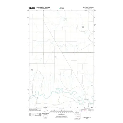
2011 Map of Circle Bridge
USGS Topo · Published 2011About this map
The Marias River meanders through the southern portion of this Liberty County landscape, flanked by a network of drainage channels including Basin Coulee and Dugout Coulee. This 2011 survey documents a sparsely populated agricultural and ranching region characterized by long stretches of gravel roads like Moffat Rd and Schumacher Ln. Two primary crossings, the Moffat Bridge and Circle Bridge, provide essential connectivity across the river, while the Erickson Cemetery serves as a quiet landmark for local genealogical interest. The northern terrain is defined by several more coulees, such as Layton Coulee and Larson Coulee, which feed into Cottonwood Creek. The map illustrates a rural Montana environment where transport and topography are inextricably linked to the seasonal flow of the river and its tributary coulees.
Find a feature on this map
18 named features on this map. Tap any name to fly to it.
Don’t see what you’re looking for? This feature index may not catch every label — zoom into the map to look around manually.
Map Details
Editions of this 2011 Circle Bridge Map
This is the sole edition of this map. No revisions or reprints were ever made.
Other maps of this area

1954 · Shelby
USGS Topo · 1:250,000

1958 · Shelby
USGS Topo · 1:250,000

1970 · Circle Bridge
USGS Topo · 1:24,000

1970 · Poverty Coulee NE
USGS Topo · 1:24,000

1970 · Penzer School
USGS Topo · 1:24,000

1970 · Uphill Creek
USGS Topo · 1:24,000

1970 · Sagebrush Coulee
USGS Topo · 1:24,000

1970 · Poverty Coulee SE
USGS Topo · 1:24,000

1970 · Goose Bill Butte NW
USGS Topo · 1:24,000

1970 · Poverty Coulee
USGS Topo · 1:24,000