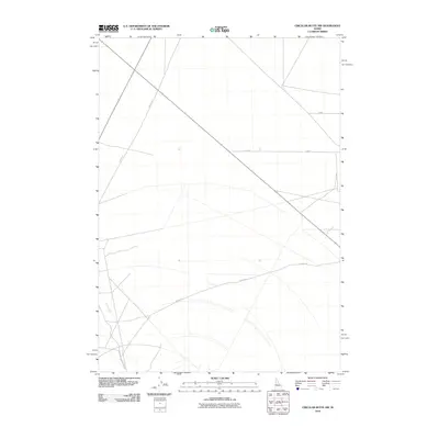
2010 Map of Circular Butte NW
USGS Topo · Published 2010About this map
Birch Creek flows through the southwestern corner of this high desert landscape in Jefferson County, which is defined by its austere topography and sparse network of service roads. The map captures a transition between the open sagebrush steppe and the early twentieth-century infrastructure of the region. Diagonal and rectilinear routes such as Cutoff Rd, E 2300 N, and 2400n crisscross the terrain, suggesting a landscape managed for agricultural access and utility. This 2010 survey provides a clean view of the northern Snake River Plain's character, where the intersection of hydrology and desert transport routes remains the primary footprint of human presence.
Find a feature on this map
4 named features on this map. Tap any name to fly to it.
Don’t see what you’re looking for? This feature index may not catch every label — zoom into the map to look around manually.
Map Details
Editions of this 2010 Circular Butte NW Map
This is the sole edition of this map. No revisions or reprints were ever made.
Other maps of this area

1955 · Dubois
USGS Topo · 1:250,000

1955 · Idaho Falls
USGS Topo · 1:250,000

1958 · Dubois
USGS Topo · 1:250,000

1958 · Idaho Falls
USGS Topo · 1:250,000

1969 · Lidy Hot Springs SE
USGS Topo · 1:24,000

1969 · Antelope Butte
USGS Topo · 1:24,000

1969 · Circular Butte
USGS Topo · 1:24,000

1969 · Circular Butte NW
USGS Topo · 1:24,000

1969 · Richard Butte
USGS Topo · 1:24,000
1969 · Monteview
USGS Topo · 1:24,000