
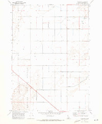
1969 Map of Circular Butte NW
USGS Topo · Published 1973About this map
National Reactor Testing Station lands dominate this high desert landscape, which sits at the intersection of several county boundaries in eastern Idaho. The 1969 field survey reveals a sparsely developed environment defined primarily by industrial and utility infrastructure, including a prominent network of fence lines and access roads cutting across the terrain. Water resources are limited in this arid region, marked by the presence of Birch Creek and scattered infrastructure such as a Well to support operations. Industrial activity is evidenced by small-scale extraction sites like a Gravel Pit and a Borrow Pit, typical of the region's mid-century development for testing and research facilities. The map captures a specific moment in the expansion of federal scientific research sites, showing the transition from open range to a controlled technological corridor.
Find a feature on this map
8 named features on this map. Tap any name to fly to it.
Don’t see what you’re looking for? This feature index may not catch every label — zoom into the map to look around manually.
Map Details
Editions of this 1969 Circular Butte NW Map
This is the sole edition of this map. No revisions or reprints were ever made.
Other maps of this area

1955 · Dubois
USGS Topo · 1:250,000

1955 · Idaho Falls
USGS Topo · 1:250,000

1958 · Dubois
USGS Topo · 1:250,000

1958 · Idaho Falls
USGS Topo · 1:250,000

1969 · Lidy Hot Springs SE
USGS Topo · 1:24,000

1969 · Antelope Butte
USGS Topo · 1:24,000

1969 · Circular Butte
USGS Topo · 1:24,000

1969 · Richard Butte
USGS Topo · 1:24,000
1969 · Monteview
USGS Topo · 1:24,000

1969 · Big Lost River Sinks
USGS Topo · 1:24,000