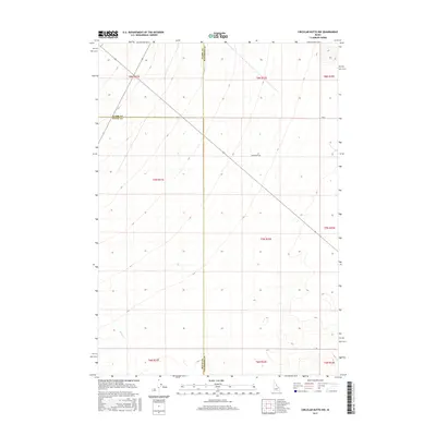
2017 Map of Circular Butte NW
USGS Topo · Published 2017About this map
The Clark Co Jefferson Co and Clark Co Butte Co boundaries intersect in this arid stretch of eastern Idaho, where the landscape is defined by vast volcanic plains and sparse water resources. The ephemeral path of Birch Cr crosses the southwestern corner of the quadrangle, representing one of the few hydrological features in an otherwise dry volcanic terrain. Human activity is minimal, marked primarily by the passage of Wadsworth Rd and various section lines of the Public Land Survey System. The map documents the convergence of several townships, including t7n r31e and t7n r32e, illustrating the precise grid work imposed on this open country near the northern edge of the Snake River Plain.
Find a feature on this map
14 named features on this map. Tap any name to fly to it.
Don’t see what you’re looking for? This feature index may not catch every label — zoom into the map to look around manually.
Map Details
Editions of this 2017 Circular Butte NW Map
This is the sole edition of this map. No revisions or reprints were ever made.
Other maps of this area

1955 · Dubois
USGS Topo · 1:250,000

1955 · Idaho Falls
USGS Topo · 1:250,000

1958 · Dubois
USGS Topo · 1:250,000

1958 · Idaho Falls
USGS Topo · 1:250,000

1969 · Lidy Hot Springs SE
USGS Topo · 1:24,000

1969 · Antelope Butte
USGS Topo · 1:24,000

1969 · Circular Butte
USGS Topo · 1:24,000

1969 · Circular Butte NW
USGS Topo · 1:24,000

1969 · Richard Butte
USGS Topo · 1:24,000
1969 · Monteview
USGS Topo · 1:24,000