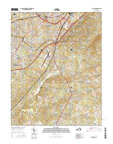
2016 Map of City Farm
USGS Topo · Published 2016About this map
Lynchburg and its southern suburbs define the landscape of this 2016 survey, where industrial and educational centers meet the rural reaches of Campbell Co. The map detail captures a significant era of institutional growth, highlighted by Liberty Univ and Central Virginia Community Coll near the northern border, while Lynchburg Regional Airport/Preston Glenn Field serves as a major transportation hub for the region. Beyond the urbanized areas of Brookville and Southland Acres, the terrain shifts toward small settlements like Lawyers and Yellow Branch. Genealogists will find a high density of burial grounds throughout the countryside, including the Merryman Cem, Dodson Cem, and Reynolds Cem. Waterways such as Flat Cr and Beaver Cr traverse the county, winding past long-established points like Brush Tavern and the county seat at Rustburg.
Find a feature on this map
285 named features on this map. Tap any name to fly to it.
Don’t see what you’re looking for? This feature index may not catch every label — zoom into the map to look around manually.
Map Details
Editions of this 2016 City Farm Map
This is the sole edition of this map. No revisions or reprints were ever made.
Other maps of this area

1892 · Lynchburg
USGS Topo · 1:125,000

1944 · Lynchburg
USGS Topo · 1:62,500

1947 · Roanoke
USGS Topo · 1:250,000

1950 · Goode
USGS Topo · 1:62,500

1950 · Lynchburg
USGS Topo · 1:62,500

1951 · Altavista
USGS Topo · 1:62,500

1956 · Gladys
USGS Topo · 1:62,500

1959 · Roanoke
USGS Topo · 1:250,000

1963 · Roanoke
USGS Topo · 1:250,000
1963 · Kelly
USGS Topo · 1:24,000