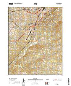
2019 Map of City Farm
USGS Topo · Published 2019About this map
Lynchburg expands southward across this Campbell County landscape, where the academic grounds of Liberty University and Central Virginia Community College meet the aviation activity at Lynchburg Regional Airport. The terrain is defined by prominent elevations such as Candler Mountain and Jack Mountain, which overlook a network of suburban developments and smaller settlements. Among these are Brookville, Southland Acres, and Vista Acres, alongside older established points like Lawyers and Yellow Branch. Genealogists and local historians can find several family and church burial grounds throughout the area, including Beulah Cemetery, Prebble Cemetery, and Merryman Cemetery. The map captures the significant hydrological system of the region, from the headwaters of Flat Creek to recreational and utility waters like Camp Hydaway Lake and Rockdale Lake.
Find a feature on this map
59 named features on this map. Tap any name to fly to it.
Don’t see what you’re looking for? This feature index may not catch every label — zoom into the map to look around manually.
Map Details
Editions of this 2019 City Farm Map
This is the sole edition of this map. No revisions or reprints were ever made.
Other maps of this area

1892 · Lynchburg
USGS Topo · 1:125,000

1944 · Lynchburg
USGS Topo · 1:62,500

1947 · Roanoke
USGS Topo · 1:250,000

1950 · Goode
USGS Topo · 1:62,500

1950 · Lynchburg
USGS Topo · 1:62,500

1951 · Altavista
USGS Topo · 1:62,500

1956 · Gladys
USGS Topo · 1:62,500

1959 · Roanoke
USGS Topo · 1:250,000

1963 · Roanoke
USGS Topo · 1:250,000
1963 · Kelly
USGS Topo · 1:24,000