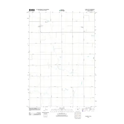
2012 Map of Claire City
USGS Topo · Published 2012About this map
The Little Minnesota River meanders through this agricultural landscape in northeastern South Dakota, marking a terrain defined by its Norwegian heritage and rural infrastructure. The small settlement of Hammer stands in the northeast, while the local civic center includes a Po and the corridor along Railroad Ave. This 2012 survey illustrates the grid-based settlement pattern of Roberts County, where the preservation of community history is evident through its numerous burial grounds. Genealogists and local historians can locate several distinct cemeteries tied to early regional identities, including Saint Boniface Cem, Nidaros Cem, Norway Cem, and Stavanger Cem. These sites, spaced along the section roads from 105th St down to 111th St, reflect the immigrant roots and ecclesiastical divisions of the families who established the homesteads across these plains.
Find a feature on this map
23 named features on this map. Tap any name to fly to it.
Don’t see what you’re looking for? This feature index may not catch every label — zoom into the map to look around manually.
Map Details
Editions of this 2012 Claire City Map
This is the sole edition of this map. No revisions or reprints were ever made.
Other maps of this area

1916 · Peever
USGS Topo · 1:62,500

1917 · New Effington
USGS Topo · 1:62,500

1918 · Peever
USGS Topo · 1:62,500

1953 · Milbank
USGS Topo · 1:250,000

1958 · Milbank
USGS Topo · 1:250,000
1964 · Claire City NE
USGS Topo · 1:24,000
1964 · Claire City NW
USGS Topo · 1:24,000

1964 · Claire City
USGS Topo · 1:24,000

1964 · Claire City SW
USGS Topo · 1:24,000

1970 · Whitestone Lake
USGS Topo · 1:24,000