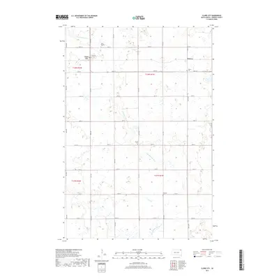
2017 Map of Claire City
USGS Topo · Published 2017About this map
Claire City serves as the primary hub in this portion of Roberts County, situated near the headwaters of the Little Minnesota River. The landscape is defined by the high density of small wetlands and prairie potholes that characterize this region of South Dakota. For those researching family history, the map provides precise locations for several religiously-affiliated burial grounds, including Saint Boniface Cem, Nidaros Cem, Norway Cem, and Stavanger Cem, reflecting the Scandinavian and European heritage of the early settlers. The rural infrastructure is organized along a strict section line grid, with the small settlement of Hammer located to the east. The river itself meanders southeast through the glacial terrain, flanked by numerous unnamed ponds and drainage features that influence the placement of local roads like Co Rd 19 and 105th St.
Find a feature on this map
22 named features on this map. Tap any name to fly to it.
Don’t see what you’re looking for? This feature index may not catch every label — zoom into the map to look around manually.
Map Details
Editions of this 2017 Claire City Map
This is the sole edition of this map. No revisions or reprints were ever made.
Other maps of this area

1916 · Peever
USGS Topo · 1:62,500

1917 · New Effington
USGS Topo · 1:62,500

1918 · Peever
USGS Topo · 1:62,500

1953 · Milbank
USGS Topo · 1:250,000

1958 · Milbank
USGS Topo · 1:250,000
1964 · Claire City NE
USGS Topo · 1:24,000
1964 · Claire City NW
USGS Topo · 1:24,000

1964 · Claire City
USGS Topo · 1:24,000

1964 · Claire City SW
USGS Topo · 1:24,000

1970 · Whitestone Lake
USGS Topo · 1:24,000