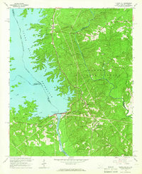
1964 Map of Clarks Hill
USGS Topo · Published 1966About this map
Clark Hill Dam anchors this mid-century survey, illustrating the massive hydrological transformation of the Savannah River valley where South Carolina and Georgia meet. The creation of the Clark Hill Reservoir has completely reshaped the landscape, drowning old riverbanks and creating the complex shorelines seen along Key Creek and Spring Creek. Despite the massive engineering of the spillway and powerhouse, the surrounding Sumter National Forest preserves a rural character defined by scattered communities like Modoc and Meriwether. Local history is visible in the network of country churches, including Bethany Ch and Asbury Mission Ch, alongside remnants of earlier infrastructure like the Old Petersburg Road. The Atlantic Coast Line railroad runs north-south through this terrain, connecting timber and small settlements to the wider region while bypassing the newly formed recreational areas and camps.
Find a feature on this map
51 named features on this map. Tap any name to fly to it.
Don’t see what you’re looking for? This feature index may not catch every label — zoom into the map to look around manually.
Map Details
Editions of this 1964 Clarks Hill Map
3 editions found
Other maps of this area

1892 · Mc Cormick
USGS Topo · 1:125,000

1912 · Mc Cormick
USGS Topo · 1:125,000

1920 · Clarks Hill
USGS Topo · 1:48,000

1921 · Clarks Hill
USGS Topo · 1:62,500

1921 · Appling
USGS Topo · 1:62,500

1941 · Clarks Hill
USGS Topo · 1:62,500

1942 · Clarks Hill
USGS Topo · 1:62,500

1943 · Appling
USGS Topo · 1:62,500

1953 · Athens
USGS Topo · 1:250,000

1958 · Athens
USGS Topo · 1:250,000