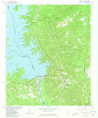
1964 Map of Clarks Hill
USGS Topo · Published 1980About this map
The Clark Hill Dam stands as the central engineering feat of this landscape, impounding the Savannah River to form the expansive Clark Hill Lake. This survey captures a region defined by water management and forest preservation, with much of the South Carolina side falling within the Sumter National Forest. The settlement pattern reflects the area's transition from river-focused transit to a modern reservoir-based economy, as seen in the numerous boat ramps and picnic areas replacing older crossings. Historical routes like the Gilchrist Ferry Road and Old Petersburg Road provide clues to earlier overland travel, while the Atlantic Coast Line Railroad snakes through the settlements of Modoc and Clarks Hill. Several country churches, including Hosannah Ch and the Asbury Mission Ch, remain as community anchors in the hilly terrain of McCormick and Edgefield counties.
Find a feature on this map
58 named features on this map. Tap any name to fly to it.
Don’t see what you’re looking for? This feature index may not catch every label — zoom into the map to look around manually.
Map Details
Editions of this 1964 Clarks Hill Map
3 editions found
Other maps of this area

1892 · Mc Cormick
USGS Topo · 1:125,000

1912 · Mc Cormick
USGS Topo · 1:125,000

1920 · Clarks Hill
USGS Topo · 1:48,000

1921 · Clarks Hill
USGS Topo · 1:62,500

1921 · Appling
USGS Topo · 1:62,500

1941 · Clarks Hill
USGS Topo · 1:62,500

1942 · Clarks Hill
USGS Topo · 1:62,500

1943 · Appling
USGS Topo · 1:62,500

1953 · Athens
USGS Topo · 1:250,000

1958 · Athens
USGS Topo · 1:250,000