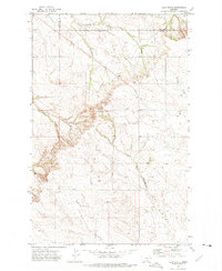
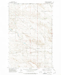
1972 Map of Clay Butte
USGS Topo · Published 1975About this map
Clay Butte stands as the central high point in this 1970s landscape, which straddles the boundary between Dawson and Richland counties. The area is defined by a dendritic network of drainage systems, including the South Fork Lisk Creek to the north and the upper reaches of the North Fork Buffalo Creek and West Fork Buffalo Creek to the south. This terrain illustrates the characteristic land use patterns of eastern Montana, where the open rangeland is punctuated only by utility infrastructure such as a Pipeline and a prominent Radio Tower. The sparse human footprint suggests a region primarily dedicated to large-scale ranching or resource management, with the topography guiding the placement of section lines and early transport routes around the base of the butte and along the watercourses like Burns Creek.
Find a feature on this map
9 named features on this map. Tap any name to fly to it.
Don’t see what you’re looking for? This feature index may not catch every label — zoom into the map to look around manually.
Map Details
Editions of this 1972 Clay Butte Map
This is the sole edition of this map. No revisions or reprints were ever made.
Other maps of this area

1909 · Glendive
USGS Topo · 1:250,000

1954 · Glendive
USGS Topo · 1:250,000

1957 · Glendive
USGS Topo · 1:250,000

1958 · Glendive
USGS Topo · 1:250,000
1972 · Red Top
USGS Topo · 1:24,000
1972 · Enid SE
USGS Topo · 1:24,000
1972 · Kuester Lake
USGS Topo · 1:24,000
1972 · Bloomfield
USGS Topo · 1:24,000
1972 · Enid
USGS Topo · 1:24,000
1981 · Glendive
USGS Topo · 1:100,000