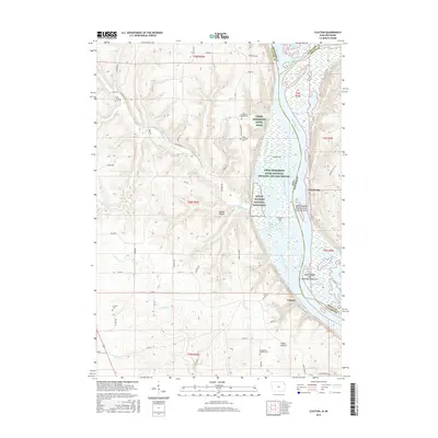
2015 Map of Clayton
USGS Topo · Published 2015About this map
The confluence of the Wisconsin River and the Mississippi River defines this riverfront landscape along the border of Iowa and Wisconsin. On the western bank, the settlement of Clayton serves as a historic point of entry to the bluffs, while across the water, Wyalusing sits near the river junction. The map documents a complex network of backwaters and named channels such as Johnsons Slough and Wyalusing Slough, which weave around several large islands including Island 176 and Island Number One Hundred Seventy-seven. Significant conservation and cultural lands dominate the river corridor, specifically the Effigy Mounds National Monument and the Upper Mississippi River National Wildlife and Fish Refuge. Genealogists will find numerous burial sites across the ridges, including the Jenkins Cem, Norsk Lutheran Cem, and Clayton Cem. The interior is marked by deep coulees like Gasner Hollow and the winding course of Sny Magill Cr.
Find a feature on this map
67 named features on this map. Tap any name to fly to it.
Don’t see what you’re looking for? This feature index may not catch every label — zoom into the map to look around manually.
Map Details
Editions of this 2015 Clayton Map
This is the sole edition of this map. No revisions or reprints were ever made.
Other maps of this area

1902 · Elkader
USGS Topo · 1:125,000

1903 · Waukon
USGS Topo · 1:125,000

1929 · Prairie Du Chien
USGS Topo · 1:62,500

1932 · Prairie Du Chien
USGS Topo · 1:62,500

1958 · La Crosse
USGS Topo · 1:250,000

1959 · Dubuque
USGS Topo · 1:250,000

1961 · Dubuque
USGS Topo · 1:250,000

1961 · La Crosse
USGS Topo · 1:250,000

1962 · Dubuque
USGS Topo · 1:250,000

1962 · Clayton
USGS Topo · 1:24,000