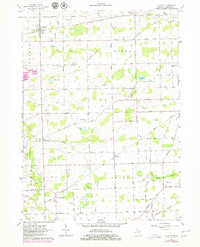
1962 Map of Clayton
USGS Topo · Published 1979About this map
The village of Clayton serves as the focal point for this survey of Lenawee County, captured in the early 1960s with updates through the late 1970s. The landscape is defined by the headwaters of the South Branch Raisin River and a dense network of agricultural drainage systems like the Bird Drain and Bordine Drain. The railway infrastructure of the New York Central and the Wabash line cuts through these rural townships, illustrating the vital role of rail transport in the mid-century agricultural economy. Notable local landmarks include several rural burial grounds such as Dover Center Cem and Porter Cem, alongside the small aviation hub at Allen Landing Strip. The presence of numerous Gravel Pits and various Oil Wells scattered across the townships of Dover, Hudson, Medina, and Seneca points to a landscape defined by natural resource extraction.
Find a feature on this map
68 named features on this map. Tap any name to fly to it.
Don’t see what you’re looking for? This feature index may not catch every label — zoom into the map to look around manually.
Map Details
Editions of this 1962 Clayton Map
Other maps of this area

1911 · Wauseon
USGS Topo · 1:62,500

1913 · Wauseon
USGS Topo · 1:62,500

1913 · Alvordton
USGS Topo · 1:62,500

1943 · Wauseon
USGS Topo · 1:62,500

1944 · Alvordton
USGS Topo · 1:62,500

1953 · Fort Wayne
USGS Topo · 1:250,000

1956 · Fort Wayne
USGS Topo · 1:250,000

1960 · Morenci
USGS Topo · 1:24,000

1960 · Fayette
USGS Topo · 1:24,000
1960 · Lyons
USGS Topo · 1:24,000