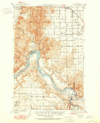
1950 Map of Clayton
USGS Topo · Published 1970About this map
Long Lake and the Spokane River dominate this 1950 topography of the borderlands between Stevens and Spokane counties. The landscape is defined by the sharp transition from the elevated Negro Mtn and Five Sisters peaks down to the expansive Four Mound Prairie and Rose Prairie. Along the eastern edge, the Great Northern railroad services the town of Clayton, while the rural interior is dotted with the community infrastructure of an earlier generation, including the Grange Hall, Happy Home Ch, and the Williams Valley Sch. Near the southern confluence, the Fort Spokane Historic Site and a Gaging Sta sit near the hydroelectric developments at Nine Mile Falls. This survey documents a mid-century moment where established valley farming communities like Williams Valley remained distinct before later regional growth.
Find a feature on this map
52 named features on this map. Tap any name to fly to it.
Don’t see what you’re looking for? This feature index may not catch every label — zoom into the map to look around manually.
Map Details
Editions of this 1950 Clayton Map
This is the sole edition of this map. No revisions or reprints were ever made.
Historical Maps of Spokane County Through Time
4 maps found