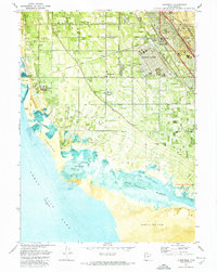
1972 Map of Clearfield
USGS Topo · Published 1974About this map
The industrial and military landscape of northern Davis County is prominently displayed here, anchored by the sprawling infrastructure of Hill Air Force Base and the Federal Depot. This 1972 survey captures a period of intense logistical activity, centered on the Freeport Center and the busy rail corridors of the Union Pacific and Denver and Rio Grande Western. These railroads parallel the shoreline of the Great Salt Lake, where the transition from irrigated farmland to the West Layton Marshes and West Kaysville Marshes is clearly marked by an Old Railroad Grade. Away from the industrial hubs, established community roots are found at West Point Cem and local institutions like Pioneer Sch and Wasatch Sch, illustrating the residential growth extending from Clearfield toward the brackish western flats.
Find a feature on this map
42 named features on this map. Tap any name to fly to it.
Don’t see what you’re looking for? This feature index may not catch every label — zoom into the map to look around manually.
Map Details
Editions of this 1972 Clearfield Map
This is the sole edition of this map. No revisions or reprints were ever made.
Other maps of this area

1885 · Salt Lake
USGS Topo · 1:250,000

1885 · Tooele Valley
USGS Topo · 1:250,000

1925 · Ft. Douglas
USGS Topo · 1:125,000

1928 · Ft. Douglas
USGS Topo · 1:125,000

1952 · Saltair NE
USGS Topo · 1:24,000

1952 · Farmington
USGS Topo · 1:24,000

1953 · Tooele
USGS Topo · 1:250,000

1954 · Antelope Island
USGS Topo · 1:24,000

1954 · Antelope Island North
USGS Topo · 1:24,000

1954 · Salt Lake City
USGS Topo · 1:250,000