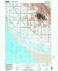
1999 Map of Clearfield
USGS Topo · Published 2001About this map
Great Salt Lake dominates the southwestern quadrant of this study, its fluctuating shoreline defined here by the West Layton Marshes and the Howard Slough State Waterfowl Management Area. In the late 1990s, the urban corridor between Clinton and Layton reveals a landscape of rapid residential expansion intermixed with significant industrial and military infrastructure. The sprawling Freeport Center stands as a massive logistical hub adjacent to the Union Pacific rail lines, while the northwestern corner is occupied by the extensive reach of Hill Air Force Base. Moving west from the density of Clearfield, the terrain transitions to the agricultural and suburban patterns of Syracuse and West Point, where irrigation is managed through the Davis-Weber Canal and Hooper Canal. Local history is anchored by sites like the West Point Cemetery and numerous neighborhood schools including Stoker Sch and Wasatch Sch.
Find a feature on this map
50 named features on this map. Tap any name to fly to it.
Don’t see what you’re looking for? This feature index may not catch every label — zoom into the map to look around manually.
Map Details
Editions of this 1999 Clearfield Map
This is the sole edition of this map. No revisions or reprints were ever made.
Other maps of this area

1885 · Salt Lake
USGS Topo · 1:250,000

1885 · Tooele Valley
USGS Topo · 1:250,000

1925 · Ft. Douglas
USGS Topo · 1:125,000

1928 · Ft. Douglas
USGS Topo · 1:125,000

1952 · Saltair NE
USGS Topo · 1:24,000

1952 · Farmington
USGS Topo · 1:24,000

1953 · Tooele
USGS Topo · 1:250,000

1954 · Antelope Island
USGS Topo · 1:24,000

1954 · Antelope Island North
USGS Topo · 1:24,000

1954 · Salt Lake City
USGS Topo · 1:250,000