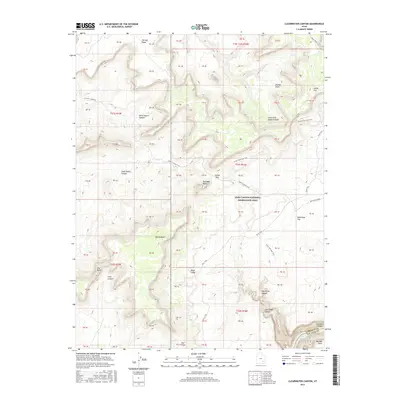
2017 Map of Clearwater Canyon
USGS Topo · Published 2017About this map
Glen Canyon National Recreation Area dominates this remote landscape where the high desert plateau breaks into a complex network of sheer-walled drainages. The Orange Cliffs and Lands End mark the dramatic northern heights, providing a backdrop for the long descent through North Hatch Canyon and South Hatch Canyon. This 2017 survey details the primitive access routes that have served this corner of the Colorado Plateau for generations, including the storied Flint Trail and the Hatch Canyon Trail, which wind through topographic obstacles like Sunset Pass and Gunsight Butte. At the southern edge, the terrain drops precipitously into Cataract Canyon, meeting the upper reaches of Lake Powell near Bowdie Point. This record is particularly valuable for tracing the physical geography of the Clearwater Canyon watershed and the isolation of landmarks like The Big Ridge and Waterhole Flat.
Find a feature on this map
28 named features on this map. Tap any name to fly to it.
Don’t see what you’re looking for? This feature index may not catch every label — zoom into the map to look around manually.
Map Details
Editions of this 2017 Clearwater Canyon Map
This is the sole edition of this map. No revisions or reprints were ever made.
Other maps of this area

1885 · San Rafael
USGS Topo · 1:250,000

1886 · Henry Mountains
USGS Topo · 1:250,000

1892 · Henry Mountains
USGS Topo · 1:250,000

1952 · Mouth of Dark Canyon
USGS Topo · 1:62,500

1952 · Hite
USGS Topo · 1:62,500

1953 · Orange Cliffs 3 SE
USGS Topo · 1:24,000

1953 · Orange Cliffs 4 NW
USGS Topo · 1:24,000

1953 · Orange Cliffs 4 NE
USGS Topo · 1:24,000

1953 · Orange Cliffs 3 NE
USGS Topo · 1:24,000

1953 · Orange Cliffs 4 SW
USGS Topo · 1:24,000