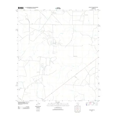
2012 Map of Clegg SW
USGS Topo · Published 2012About this map
Campana Oil Field and Labbe Oil Field dominate this landscape of resource extraction and ranching in South Texas. This 2012 survey of McMullen County reveals a terrain shaped by the energy industry and water management, where named water sources like Jug Tank, Rincon Windmill, and Soda Windmill indicate the vital importance of irrigation and livestock support in an arid environment. The map shows a network of local infrastructure, including Farm-to-Market Road 624 and several county roads that connect remote production sites. For genealogists, the presence of Campos Cem in the southwest corner provides a specific point of local historical interest. The drainage patterns of Cow Cr and Lagarto Cr carve through the brush country, illustrating the natural geography that dictates the placement of roads and industrial fields across this portion of the Texas coastal plain.
Find a feature on this map
19 named features on this map. Tap any name to fly to it.
Don’t see what you’re looking for? This feature index may not catch every label — zoom into the map to look around manually.
Map Details
Editions of this 2012 Clegg SW Map
This is the sole edition of this map. No revisions or reprints were ever made.
Other maps of this area

1920 · Mikeska
USGS Topo · 1:125,000

1937 · Loma Alta
USGS Topo · 1:62,500

1953 · Crystal City
USGS Topo · 1:250,000

1955 · Crystal City
USGS Topo · 1:250,000

1956 · Rosita Ranch
USGS Topo · 1:62,500

1956 · Freer
USGS Topo · 1:62,500

1956 · Laredo
USGS Topo · 1:250,000

1961 · Crystal City
USGS Topo · 1:250,000

1968 · Crystal City
USGS Topo · 1:250,000
1969 · Clegg
USGS Topo · 1:24,000