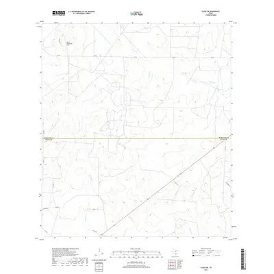
2019 Map of Clegg SW
USGS Topo · Published 2019About this map
The boundary between McMullen and Duval Counties bisects this South Texas ranch land, where the drainage network reveals the subtle topography of the Brush Country. Ephemeral waterways like Lagarto Cr and San Diego Cr thread through the landscape, eventually leading toward the Gulf Coast. In the northwest corner, the Devils Waterhole Hills rise as a localized elevation landmark above the surrounding flats. Human presence is defined by a thin network of rural roads and cattle tanks, such as Jug Tank. The isolated Campos Cem in the southwest provides a specific point of interest for genealogists tracing local families in this sparsely populated border region, while thoroughfares like FM 624 and Co RD 115 facilitate movement across the scrubland and private ranch holdings.
Find a feature on this map
14 named features on this map. Tap any name to fly to it.
Don’t see what you’re looking for? This feature index may not catch every label — zoom into the map to look around manually.
Map Details
Editions of this 2019 Clegg SW Map
This is the sole edition of this map. No revisions or reprints were ever made.
Other maps of this area

1920 · Mikeska
USGS Topo · 1:125,000

1937 · Loma Alta
USGS Topo · 1:62,500

1953 · Crystal City
USGS Topo · 1:250,000

1955 · Crystal City
USGS Topo · 1:250,000

1956 · Rosita Ranch
USGS Topo · 1:62,500

1956 · Freer
USGS Topo · 1:62,500

1956 · Laredo
USGS Topo · 1:250,000

1961 · Crystal City
USGS Topo · 1:250,000

1968 · Crystal City
USGS Topo · 1:250,000
1969 · Clegg
USGS Topo · 1:24,000