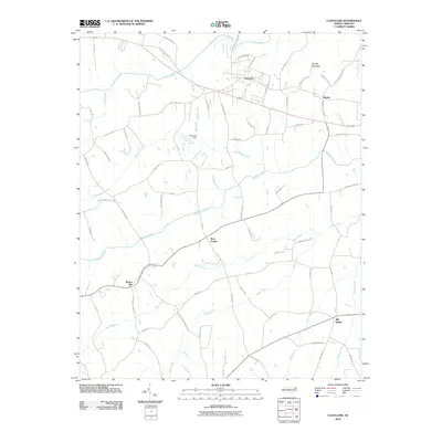
2010 Map of Cleveland
USGS Topo · Published 2010About this map
The settlement of Cleveland anchors this rural Rowan County landscape, which remains defined by its network of named creeks and crossroads. In 2010, the area near Barber highlights the intersection of local history and transport, while the surrounding terrain is marked by significant watercourses including Third Creek, Withrow Creek, and Back Creek. These streams historically dictated the placement of communities like Bear Poplar and Mount Ulla, where family-named roads such as Joe Rankin Rd and Ketchie Rd suggest generations of local heritage.
Find a feature on this map
66 named features on this map. Tap any name to fly to it.
Don’t see what you’re looking for? This feature index may not catch every label — zoom into the map to look around manually.
Map Details
Editions of this 2010 Cleveland Map
This is the sole edition of this map. No revisions or reprints were ever made.
Other maps of this area

1893 · Statesville
USGS Topo · 1:125,000

1953 · Charlotte
USGS Topo · 1:250,000

1954 · Charlotte
USGS Topo · 1:250,000

1960 · Charlotte
USGS Topo · 1:250,000

1962 · Charlotte
USGS Topo · 1:250,000

1969 · Cooleemee
USGS Topo · 1:24,000

1969 · Cool Springs
USGS Topo · 1:24,000

1969 · Shepherds
USGS Topo · 1:24,000
1969 · Mooresville
USGS Topo · 1:24,000
1969 · Rowan Mills
USGS Topo · 1:24,000