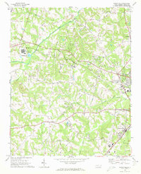
1969 Map of Rowan Mills
USGS Topo · Published 1972About this map
Southern railroad tracks bisect this North Carolina landscape, connecting the rural communities of Barber and Rowan Mills as the industrial footprint of Salisbury expands from the east. The terrain is defined by a dense network of waterways, including Second Creek, Withrow Creek, and Grants Creek, which dictated the early placement of landmarks like Mill Bridge. The map reveals a transition from traditional agrarian life to modern infrastructure, evidenced by the numerous country churches such as St Matthews Ch and Salem Ch standing alongside newer developments like the Rowan County Airport and Radio Towers (WSAT). This period shows the emergence of utilities through various pipelines and industrial features, including Industrial Waste Ponds near Barber. For genealogists and local historians, the sheet offers a precise record of neighborhood anchors like Hurley Sch and Macedonia Ch before further suburbanization altered the county's character.
Find a feature on this map
38 named features on this map. Tap any name to fly to it.
Don’t see what you’re looking for? This feature index may not catch every label — zoom into the map to look around manually.
Map Details
Editions of this 1969 Rowan Mills Map
2 editions found
Other maps of this area

1893 · Statesville
USGS Topo · 1:125,000

1950 · Churchland
USGS Topo · 1:24,000

1951 · Churchland
USGS Topo · 1:24,000

1953 · Charlotte
USGS Topo · 1:250,000

1954 · Charlotte
USGS Topo · 1:250,000

1960 · Charlotte
USGS Topo · 1:250,000

1962 · Charlotte
USGS Topo · 1:250,000
1962 · Salisbury
USGS Topo · 1:24,000
1962 · Rockwell
USGS Topo · 1:24,000

1969 · Cooleemee
USGS Topo · 1:24,000