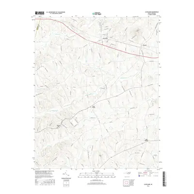
2016 Map of Cleveland
USGS Topo · Published 2016About this map
Cleveland and its neighboring rural crossroads define the landscape of western Rowan County in this mid-2010s documentation. The Norfolk Southern rail line cuts a straight path across the northern terrain, passing through the junction at Barber and past the slopes of Youngs Mtn. This area is characterized by a dense network of local roads that connect historic farming communities, such as Bear Poplar and Mount Ulla, which sit among the headwaters of numerous waterways including Withrow Creek and Sills Cr. In the southern portion of the map, the airstrip at Corriher Field reflects modern aviation needs while Mill Bridge marks a traditional point of crossing over Kerr Cr. The survey illustrates the persistence of these established settlements as residential and transit hubs within the Piedmont's rolling drainage basins.
Find a feature on this map
99 named features on this map. Tap any name to fly to it.
Don’t see what you’re looking for? This feature index may not catch every label — zoom into the map to look around manually.
Map Details
Editions of this 2016 Cleveland Map
This is the sole edition of this map. No revisions or reprints were ever made.
Other maps of this area

1893 · Statesville
USGS Topo · 1:125,000

1953 · Charlotte
USGS Topo · 1:250,000

1954 · Charlotte
USGS Topo · 1:250,000

1960 · Charlotte
USGS Topo · 1:250,000

1962 · Charlotte
USGS Topo · 1:250,000

1969 · Cooleemee
USGS Topo · 1:24,000

1969 · Cool Springs
USGS Topo · 1:24,000

1969 · Shepherds
USGS Topo · 1:24,000
1969 · Mooresville
USGS Topo · 1:24,000
1969 · Rowan Mills
USGS Topo · 1:24,000