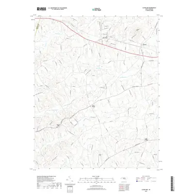
2019 Map of Cleveland
USGS Topo · Published 2019About this map
Cleveland serves as the primary hub in this portion of western Rowan County, where the NS rail line and Old US Hwy 70 intersect near the prominent Youngs Mtn. The landscape is defined by a dense network of watercourses, including Third Creek, Withrow Creek, and Beaverdam Cr, which carve through the terrain between established crossroads. Several small, historic communities such as Bear Poplar, Mount Ulla, and Mill Bridge are visible, connected by a web of local routes like Sherrills Ford Rd and Back Creek Church Rd. The presence of Corriher Field and numerous named roads reflecting local family lineages, such as McNeely Rd and Graham Rd, provides significant detail for those studying the rural development and land ownership patterns of this Piedmont region.
Find a feature on this map
97 named features on this map. Tap any name to fly to it.
Don’t see what you’re looking for? This feature index may not catch every label — zoom into the map to look around manually.
Map Details
Editions of this 2019 Cleveland Map
This is the sole edition of this map. No revisions or reprints were ever made.
Other maps of this area

1893 · Statesville
USGS Topo · 1:125,000

1953 · Charlotte
USGS Topo · 1:250,000

1954 · Charlotte
USGS Topo · 1:250,000

1960 · Charlotte
USGS Topo · 1:250,000

1962 · Charlotte
USGS Topo · 1:250,000

1969 · Cooleemee
USGS Topo · 1:24,000

1969 · Cool Springs
USGS Topo · 1:24,000

1969 · Shepherds
USGS Topo · 1:24,000
1969 · Mooresville
USGS Topo · 1:24,000
1969 · Rowan Mills
USGS Topo · 1:24,000