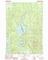
1990 Map of Clifford Lake
USGS Topo · Published 1990About this map
Clifford Lake dominates this 1990 Washington County landscape, its sprawling fingers defined by the West Arm, East Arm, and the central Middle Ground. The terrain is characterized by a complex network of glacial features and water bodies, including North Beaverdam Lake and the curious pair of Hosea Pug Lake and Silver Pug Lake. High points like Harmon Mountain and Grey Mountain provide topographic relief amidst the wetlands and logging territory. The region is divided by the boundaries of Plantation No 21 and Crawford, showing a remote Maine landscape largely shaped by timber and water. A handful of campsites and a sand and gravel pit along Scott Brook hint at the seasonal recreation and resource extraction that sustain these townships.
Find a feature on this map
36 named features on this map. Tap any name to fly to it.
Don’t see what you’re looking for? This feature index may not catch every label — zoom into the map to look around manually.
Map Details
Editions of this 1990 Clifford Lake Map
This is the sole edition of this map. No revisions or reprints were ever made.
Other maps of this area

1941 · Wesley
USGS Topo · 1:62,500

1941 · Tug Mountain
USGS Topo · 1:62,500

1941 · Big Lake
USGS Topo · 1:62,500

1941 · Wabassus Lake
USGS Topo · 1:62,500

1943 · Big Lake
USGS Topo · 1:62,500

1943 · Tug Mountain
USGS Topo · 1:62,500

1943 · Wesley
USGS Topo · 1:62,500

1943 · Wabassus Lake
USGS Topo · 1:62,500

1952 · Big Lake
USGS Topo · 1:50,000

1953 · Wabassus Lake
USGS Topo · 1:62,500