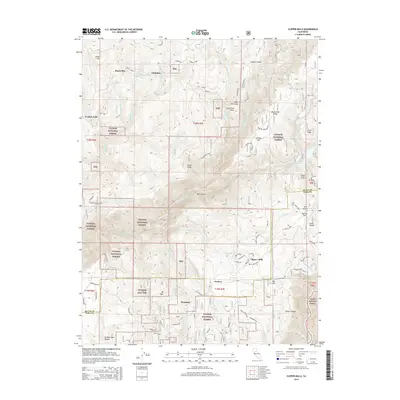
2015 Map of Clipper Mills
USGS Topo · Published 2015About this map
Clipper Mills and Woodleaf anchor this survey of the Sierra Nevada foothills, where the Butte Co Yuba Co line divides a landscape shaped by timber and water. The terrain is defined by dramatic elevation changes between the S Fork Feather River and high ridgelines like Lumpkin Ridge and Empire Ridge. Historic transport routes, notably the winding La Porte Rd and Old Knox Rd, connect small settlements that grew alongside the gold and timber industries. This region is heavily managed within the Plumas National Forest and Tahoe National Forest, showing a network of forest service roads and drainage basins such as Lost Cr Reservoir and Oroleve Cr. Smaller named localities like Rogerville and Lumpkin point to the area's history of isolated homesteading and specialized mountain camps.
Find a feature on this map
59 named features on this map. Tap any name to fly to it.
Don’t see what you’re looking for? This feature index may not catch every label — zoom into the map to look around manually.
Map Details
Editions of this 2015 Clipper Mills Map
This is the sole edition of this map. No revisions or reprints were ever made.
Other maps of this area

1888 · Smartsville
USGS Topo · 1:125,000

1888 · Bidwell Bar
USGS Topo · 1:125,000

1891 · Bidwell Bar
USGS Topo · 1:125,000

1891 · Smartsville
USGS Topo · 1:125,000

1892 · Smartsville
USGS Topo · 1:125,000

1893 · Bidwell Bar
USGS Topo · 1:125,000

1894 · Smartsville
USGS Topo · 1:125,000

1895 · Bidwell Bar
USGS Topo · 1:125,000

1895 · Smartsville
USGS Topo · 1:125,000

1897 · Bidwell Bar
USGS Topo · 1:125,000