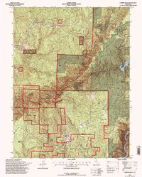
1994 Map of Clipper Mills
USGS Topo · Published 1997About this map
Clipper Mills and the high ridges of the Plumas National Forest define this 1990s landscape near the Butte and Yuba County line. The map highlights a complex water-management network essential to the region's development, including the Forbestown Canal, the Oroville Canal, and the Wyandotte Siphon. These features, alongside the Grizzly Creek Dam and Lost Creek Dam, illustrate the heavy engineering required to divert mountain water for downstream use.
Find a feature on this map
40 named features on this map. Tap any name to fly to it.
Don’t see what you’re looking for? This feature index may not catch every label — zoom into the map to look around manually.
Map Details
Editions of this 1994 Clipper Mills Map
This is the sole edition of this map. No revisions or reprints were ever made.
Other maps of this area

1888 · Smartsville
USGS Topo · 1:125,000

1888 · Bidwell Bar
USGS Topo · 1:125,000

1891 · Bidwell Bar
USGS Topo · 1:125,000

1891 · Smartsville
USGS Topo · 1:125,000

1892 · Smartsville
USGS Topo · 1:125,000

1893 · Bidwell Bar
USGS Topo · 1:125,000

1894 · Smartsville
USGS Topo · 1:125,000

1895 · Bidwell Bar
USGS Topo · 1:125,000

1895 · Smartsville
USGS Topo · 1:125,000

1897 · Bidwell Bar
USGS Topo · 1:125,000