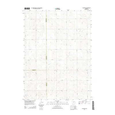
2014 Map of Closter NE
USGS Topo · Published 2014About this map
The tri-county intersection of Madison, Boone, and Antelope counties defines this rural landscape in the northeast corner of Nebraska. The terrain is characterized by a series of north-south flowing drainages, including the meandering Buffalo Cr and Giles Cr, which cut through the agricultural highlands. This 2014 survey documents a strictly rectilinear grid of section-line roads, such as 839th Rd and 535th Ave, that have persisted as the primary means of navigation through the hills. State highway Ne-45 serves as the central north-south corridor, following the county line and providing a link between the scattered farmsteads. The map is a precise record of late-modern rural land division, where the natural paths of Dry Cr and Deer Cr provide the only variation in an otherwise orderly surveyors' grid.
Find a feature on this map
24 named features on this map. Tap any name to fly to it.
Don’t see what you’re looking for? This feature index may not catch every label — zoom into the map to look around manually.
Map Details
Editions of this 2014 Closter NE Map
This is the sole edition of this map. No revisions or reprints were ever made.
Other maps of this area

1955 · Sioux City
USGS Topo · 1:250,000

1955 · Fremont
USGS Topo · 1:250,000

1957 · Fremont
USGS Topo · 1:250,000

1958 · Sioux City
USGS Topo · 1:250,000

1958 · Fremont
USGS Topo · 1:250,000

1959 · Sioux City
USGS Topo · 1:250,000

1963 · Closter SW
USGS Topo · 1:24,000
1963 · Oakdale
USGS Topo · 1:24,000

1963 · Emerick
USGS Topo · 1:24,000

1963 · Meadow Grove
USGS Topo · 1:24,000